किसी भी निर्माण परियोजना की सफलता के लिए सटीक निर्माण माप महत्वपूर्ण है। मापों में सटीकता सुनिश्चित करने से सीधे तौर पर किसी परियोजना की सुरक्षा, दक्षता और लागत-प्रभावीता पर प्रभाव पड़ सकता है। जब माप बंद हो जाते हैं, तो इससे सामग्री में महत्वपूर्ण अधिशेष, समय सीमा में देरी और संभावित सुरक्षा जोखिम हो सकते हैं। इसलिए, परियोजना प्रबंधकों और इंजीनियरों के लिए निर्माण स्थलों को मापने और मानचित्रण करने के लिए विश्वसनीय तकनीक का उपयोग करना आवश्यक है ताकि नियंत्रण बनाए रखा जा सके और डिजाइन योजनाओं और विनिर्देशों का पालन किया जा सके।
आरटीके जीपीएस या रियल-टाइम किनेमेटिक जीपीएस, जमीनी संदर्भ स्टेशनों का उपयोग करके ऐसी सटीकता प्राप्त करने में एक तकनीकी प्रगति का प्रतिनिधित्व करता है। पारंपरिक जीपीएस प्रणालियों के विपरीत जो केवल उपग्रह संकेतों पर निर्भर करती हैं, आरटीके जीपीएस वास्तविक समय में सुधार डेटा प्रदान करने के लिए बेस स्टेशनों के रूप में जाने जाने वाले ग्राउंड स्टेशनों के नेटवर्क का उपयोग करता है। ये बेस स्टेशन इन आंकड़ों को फील्ड में इस्तेमाल किए जाने वाले रोवर इकाइयों को भेजते हैं, जिससे स्थिति संबंधी आंकड़ों की तत्काल सुधार की अनुमति मिलती है। वायुमंडलीय विकृतियों और उपग्रह समय संबंधी समस्याओं जैसी त्रुटियों की भरपाई करके, आरटीके जीपीएस सेंटीमीटर स्तर की सटीकता प्राप्त करता है।
आरटीके जीपीएस द्वारा दी जाने वाली बेहतर सटीकता पारंपरिक जीपीएस विधियों के मुकाबले महत्वपूर्ण लाभ प्रदान करती है। जबकि मानक जीपीएस मीटर स्तर की सटीकता प्रदान कर सकता है, आरटीके जीपीएस इसे उच्च परिशुद्धता जैसे निर्माण, सर्वेक्षण और इंजीनियरिंग की मांग करने वाले अनुप्रयोगों के लिए उपयुक्त स्तर तक परिष्कृत करता है। यह सटीकता यह सुनिश्चित करती है कि निर्माण परियोजनाएं निर्दिष्ट आयामों और आवश्यकताओं का पालन करें, त्रुटियों, सामग्री अपशिष्ट और पुनः कार्य को कम करें। आरटीके जीपीएस के साथ, निर्माण पेशेवर सटीक स्थिति डेटा पर भरोसा कर सकते हैं, जिससे परियोजना परिणामों में सुधार और परिचालन दक्षता में वृद्धि होती है।
आरटीके जीपीएस माप सेंटीमीटर स्तर की सटीकता प्रदान करते हैं, जिससे निर्माण परियोजनाओं को तंग सहिष्णुता और सटीक विनिर्देशों का पालन करने में सक्षम बनाता है। इस तरह की उच्च स्तर की सटीकता प्राप्त करने से यह सुनिश्चित होता है कि परियोजनाएं डिजाइन और कानूनी मानकों दोनों को पूरा करें, पुनर्मूल्यांकन की आवश्यकता और महंगी त्रुटियों की संभावना को कम करें। भवन के घटकों को सही ढंग से संरेखित करने और योजना के अनुसार बुनियादी ढांचे का निर्माण सुनिश्चित करने के लिए सटीक स्थिति आवश्यक है।
इसके अतिरिक्त आरटीके जीपीएस वास्तविक समय में डेटा संग्रह की अनुमति देता है, जिससे निर्णय लेने की प्रक्रियाओं में काफी सुधार होता है और परियोजना में देरी कम होती है। वास्तविक समय की निगरानी का अर्थ है कि समायोजन तुरंत किए जा सकते हैं, लंबे समय तक व्यवधानों को रोकते हैं जो अन्यथा समयरेखा को प्रभावित कर सकते हैं। स्थान पर सटीक डेटा एकत्र करने की क्षमता साइट पर बार-बार यात्रा करने की आवश्यकता को कम करती है, जिससे दक्षता बढ़ जाती है और समय की बचत होती है।
आंकड़ों से पता चलता है कि आरटीके जीपीएस पारंपरिक तरीकों की तुलना में परियोजना की दक्षता में सुधार करता है और त्रुटियों को कम करता है। उदाहरण के लिए, आरटीके जीपीएस का उपयोग करने वाली निर्माण परियोजनाओं में त्रुटियों में 15% से अधिक की कमी देखी जा सकती है, जिससे सुचारू संचालन और परियोजना के मील के पत्थर को अधिक विश्वसनीयता से प्राप्त किया जा सकता है। सटीकता में यह वृद्धि न केवल निर्माण कार्यप्रवाहों को सुव्यवस्थित करती है बल्कि परियोजना की समग्र गुणवत्ता को भी बढ़ाती है।
निर्माण उद्योग में, RTK GPS का उपयोग साइट सर्वेक्षण और लेआउट कार्यों के लिए व्यापक रूप से किया जाता है, जिससे इन प्रक्रियाओं को काफी सरल बनाया जाता है। आरटीके जीपीएस सेंटीमीटर स्तर की सटीकता प्रदान करता है, जिससे सर्वेयर भूमि सीमाओं, स्थलाकृतिक विशेषताओं और साइट लेआउट को जल्दी और सटीक रूप से निर्धारित कर सकते हैं। यह सटीकता सुनिश्चित करती है कि निर्माण सही पैर से शुरू हो, गलतियों को कम से कम किया जा सके जिससे महंगे देरी और पुनर्निर्माण हो सके।
आरटीके जीपीएस संरचनागत आंदोलनों की निगरानी में भी महत्वपूर्ण भूमिका निभाता है, जो निर्माण प्रक्रिया के दौरान सुरक्षा और अनुपालन सुनिश्चित करने के लिए महत्वपूर्ण है। गति पर वास्तविक समय के डेटा प्रदान करके, आरटीके जीपीएस संरचनाओं में शिफ्ट या बसने का पता लगाने में मदद करता है, जिससे इंजीनियरों को आवश्यक सुदृढीकरण या समायोजन के बारे में सूचित निर्णय लेने की अनुमति मिलती है। यह क्षमता विशेष रूप से अस्थिर मिट्टी की स्थिति वाले क्षेत्रों में स्थित उच्च वृद्धि इमारतों या संरचनाओं से संबंधित परियोजनाओं में महत्वपूर्ण है।
कई परियोजनाओं ने आरटीके जीपीएस को अपने परिचालन में सफलतापूर्वक एकीकृत किया है, जिससे इसकी बहुमुखी प्रतिभा और दक्षता का प्रदर्शन हुआ है। उदाहरण के लिए, राजमार्ग निर्माण और शहरी विकास जैसी बड़ी बुनियादी ढांचा परियोजनाएं कार्यप्रवाहों को सुव्यवस्थित करने के लिए RTK जीपीएस का व्यापक रूप से उपयोग करती हैं। वास्तविक समय के डेटा प्रदान करके, आरटीके जीपीएस तेजी से निर्णय लेने में सुविधा प्रदान करता है और परियोजना प्रबंधन को बेहतर बनाता है, जिससे परियोजना के सफल परिणामों में योगदान मिलता है।
आरटीके जीपीएस प्रौद्योगिकी विभिन्न निर्माण परियोजनाओं और वातावरणों में उल्लेखनीय बहुमुखी प्रतिभा प्रदर्शित करती है। शहरी वातावरण से लेकर दूरस्थ निर्माण स्थलों तक, आरटीके जीपीएस अनुकूलन कर सकता है, सेंटीमीटर स्तर की सटीकता प्रदान करता है जो निर्माण माप में सटीकता के लिए महत्वपूर्ण है। यह अनुकूलन क्षमता इसे विभिन्न कार्यों के लिए उपयुक्त बनाती है, जिसमें नींव डालना, संरचनाओं को संरेखित करना और प्रगति की निगरानी करना शामिल है, यह सुनिश्चित करना कि सभी निर्माण विनिर्देशों को सटीक रूप से पूरा किया जाए।
आरटीके जीपीएस की अन्य प्रौद्योगिकियों जैसे ड्रोन और बिल्डिंग सूचना मॉडलिंग (बीआईएम) के साथ एकीकरण क्षमताएं इसकी उपयोगिता को और बढ़ाती हैं। आरटीके जीपीएस को ड्रोन के साथ जोड़कर, निर्माण दल बड़ी साइटों को उच्च सटीकता के साथ जल्दी से मैप करने के लिए हवाई सर्वेक्षण कर सकते हैं। बीआईएम के साथ एकीकृत होने पर आरटीके जीपीएस डेटा डिजिटल मॉडल को समृद्ध करता है, वास्तविक समय में अपडेट प्रदान करता है और गतिशील योजना और समन्वय की सुविधा प्रदान करता है। प्रौद्योगिकियों का यह अभिसरण प्रक्रियाओं को सुव्यवस्थित करता है और त्रुटियों को कम करता है, जिससे परियोजना की समग्र दक्षता में सुधार होता है।
इसके अतिरिक्त, आरटीके जीपीएस प्रौद्योगिकी के इस आसान एकीकरण के माध्यम से टीमों के बीच सहयोग को बढ़ावा देता है। सटीक और वास्तविक समय के डेटा के साथ, विभिन्न टीमोंआर्किटेक्ट्स से लेकर साइट मैनेजरों तकविलम्ब के बिना सूचित निर्णय ले सकते हैं। इससे अधिक सहयोगात्मक कार्य वातावरण को बढ़ावा मिलता है, यह सुनिश्चित होता है कि सभी हितधारक एक ही डेटा सेट से काम कर रहे हैं, इस प्रकार परियोजना के परिणामों में सुधार होता है और गलतफहमी या त्रुटियों की संभावना कम होती है।
निर्माण अनुप्रयोगों को अनुकूलित करने के लिए सही आरटीके जीपीएस उत्पाद का चयन आवश्यक है। यहाँ तीन शीर्ष उत्पादों पर विचार करने के लिए हैंः
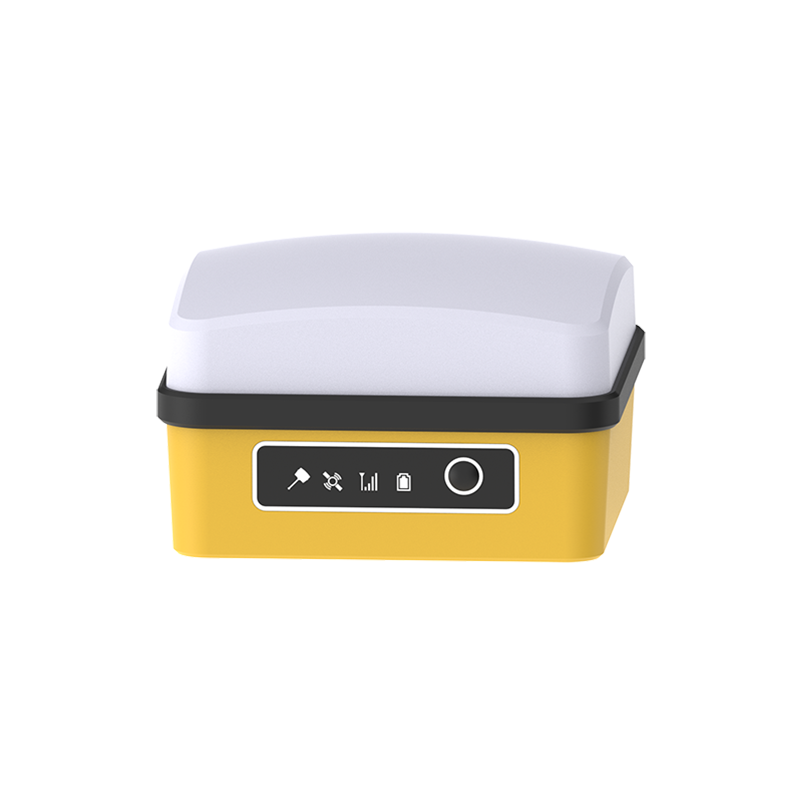
द क्यूब आरटीके लघु मात्रा पूर्ण प्रणाली एक बहुमुखी आरटीके उपग्रह लोकेटर है जो पूर्ण स्पेक्ट्रम क्षमताएं प्रदान करता है, जिससे यह निर्माण परियोजनाओं की एक विस्तृत श्रृंखला के लिए आदर्श है। यह प्रणाली बहु-आवृत्ति पोजिशनिंग और अंतर्निहित 4जी, वाईफाई और ब्लूटूथ जैसी सुविधाओं का दावा करती है, जिससे निर्बाध कनेक्टिविटी सुनिश्चित होती है। 32 जीबी स्टोरेज और 15 घंटे तक की बैटरी लाइफ के साथ, यह लंबी निर्माण अवधि के दौरान व्यापक डेटा प्रबंधन और उपयोग की अनुमति देता है।

द जीपीएस ट्रैक्टर ऑटो स्टीयरिंग सिस्टम मुख्य रूप से कृषि मशीनरी के लिए बनाया गया है, लेकिन इसके स्वचालन और सटीकता के लिए निर्माण में फायदेमंद साबित होता है। इसमें उच्च परिशुद्धता वाले बीडू उपग्रह पोजिशनिंग चिप का उपयोग किया गया है, जो 2.5 सेमी तक की सटीकता प्राप्त करता है। सिस्टम की स्थापना और उपयोगकर्ता इंटरफ़ेस का उपयोग करने में आसानी के लिए डिज़ाइन किया गया है, जिसमें विभिन्न परिचालन मोडों का समर्थन और विभिन्न गति सीमाओं में काम करने की क्षमता है।

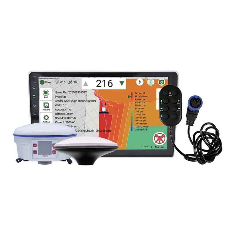
द आरटीके ग्रेडर लेवलिंग सिस्टम भूमि स्तर और ग्रेडिंग के लिए एक सुव्यवस्थित समाधान प्रदान करता है। एंड्रॉयड आधारित इंटरफेस तकनीक का उपयोग करके यह प्रणाली आसान उपयोगकर्ता बातचीत और सटीक नियंत्रण की अनुमति देती है। यह भूमि की ऊंचाई को स्वचालित रूप से मापता और गणना करता है, जिससे निर्माण कार्यों के लिए दक्षता और सटीकता में सुधार होता है जिसमें विस्तृत भूमि आकार शामिल होता है।

ये आरटीके जीपीएस उत्पाद न केवल निर्माण अनुप्रयोगों में सटीकता में सुधार करते हैं बल्कि उत्पादकता और परिचालन दक्षता में भी काफी सुधार करते हैं।
जबकि आरटीके जीपीएस तकनीक अपनी उच्च सटीकता के लिए प्रसिद्ध है, यह सिग्नल हस्तक्षेप और बेस स्टेशनों पर निर्भरता जैसी सीमाओं के साथ भी आती है। सिग्नल में बाधाएं जैसे भवन या घनी पत्तियां हो सकती हैं, जो जीपीएस इकाइयों और उपग्रहों के बीच दृष्टि रेखा को बाधित कर सकती हैं। इसके अतिरिक्त आरटीके जीपीएस प्रणालियों के इष्टतम कार्य करने के लिए उन्हें बेस स्टेशनों की एक निश्चित सीमा के भीतर रहना चाहिए, जिससे स्थिर कनेक्शन की आवश्यकता होती है जो सभी स्थानों पर संभव नहीं हो सकता है।
आरटीके जीपीएस का प्रभावी ढंग से उपयोग करने के लिए उपयोगकर्ताओं को कई सर्वोत्तम प्रथाओं का पालन करना चाहिए। एक महत्वपूर्ण कदम है स्थिति के आंकड़ों की सटीकता बनाए रखने के लिए नियमित रूप से कैलिब्रेशन करना। जीपीएस रिसीवर और उपग्रह के बीच स्पष्ट दृष्टि रेखा सुनिश्चित करना महत्वपूर्ण है, क्योंकि बाधाओं से संकेत की गुणवत्ता में गिरावट आ सकती है। इसके अतिरिक्त, उपयोगकर्ताओं को डेटा व्यवधान को रोकने के लिए बेस स्टेशन लिंक की मजबूत कवरेज और स्थिरता सुनिश्चित करनी चाहिए।
विशेषज्ञों का सुझाव है कि इन चुनौतियों को पार करने के लिए इन प्रणालियों को पूरक प्रौद्योगिकियों के साथ एकीकृत किया जाए और कार्यान्वयन स्थलों की समझदारी से योजना बनाई जाए। परियोजना क्षेत्र में कई आधार स्टेशनों का उपयोग करने से कवरेज और विश्वसनीयता में सुधार हो सकता है। इसके अतिरिक्त, उद्योग के पेशेवर उन्नत त्रुटि सुधार एल्गोरिदम का उपयोग करने और विभिन्न वातावरणों के अनुकूल होने के लिए मोबाइल या पोर्टेबल बेस स्टेशनों की खोज करने की सलाह देते हैं। इन बातों को ध्यान में रखकर उपयोगकर्ता आरटीके जीपीएस तकनीक की दक्षता और विश्वसनीयता को अधिकतम कर सकते हैं।
आरटीके जीपीएस तकनीक निर्माण में अपनी बेजोड़ सटीकता और दक्षता के लिए आवश्यक है। यह सटीक साइट माप और वास्तविक समय में सुधार की अनुमति देता है, जो निर्माण परियोजनाओं की समग्र सटीकता में सुधार करता है। जैसे-जैसे निर्माण उद्योग विकसित होता है, आरटीके जीपीएस तकनीक का महत्व बढ़ता जा रहा है, इसके विस्तार से ऑटोमेशन और स्मार्ट निर्माण प्रणालियों में इसके अनुप्रयोगों का संकेत मिलता है।
आगे देखते हुए, उद्योग के पेशेवरों को अपनी परियोजनाओं को बढ़ाने के लिए आरटीके जीपीएस समाधानों को अपनाने पर विचार करना चाहिए। यह तकनीक न केवल सटीकता में सुधार करती है बल्कि त्रुटियों और पुनः कार्य से जुड़ी लागतों को भी कम करती है, जिससे यह आधुनिक निर्माण प्रथाओं में एक मूल्यवान उपकरण बन जाता है। आरटीके जीपीएस को एकीकृत करके, पेशेवर यह सुनिश्चित कर सकते हैं कि वे आज के निर्माण वातावरण की कठोर मांगों को आत्मविश्वास और सटीकता के साथ पूरा करें।