RTK (Real-Time Kinematic) survey equipment is crucial for achieving high-accuracy positioning through satellite signals. This technology enhances the precision of Global Navigation Satellite System (GNSS) data, enabling centimeter-level accuracy. It uses real-time corrections to reduce common errors found in other methods, making RTK an essential tool for tasks that require meticulous precision.
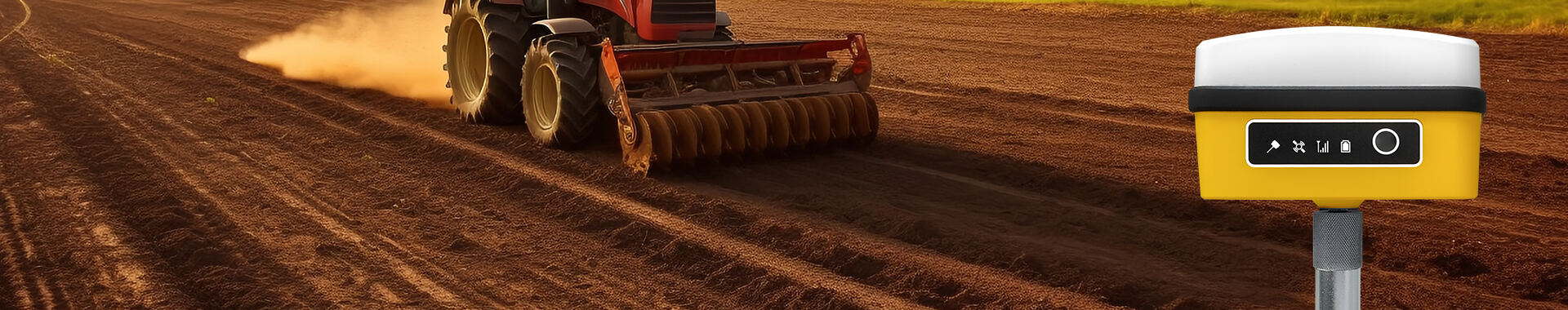
The significance of RTK survey equipment spans various applications, such as construction, agriculture, and field mapping. For example, in construction, RTK ensures that structures are built to exact specifications, which is vital for safety and structural integrity. In agriculture, RTK empowers precision farming techniques, allowing for accurate placement of inputs like seeds and fertilizers, thus maximizing yield and resource efficiency.
RTK systems comprise several components: a base station, rover, and wireless communication methods. The base station is a fixed point with known coordinates that gauges GNSS signals for error correction, which it transmits to the rover in real time. This setup, supported by robust wireless communications, ensures continuous, accurate positioning data essential for professional surveying and mapping.
When selecting RTK survey equipment, it's crucial to consider accuracy requirements specific to your industry, as these will directly impact both performance and cost. For instance, agriculture may demand high precision for tasks like planting or fertilizing, which significantly benefits from centimeter-level accuracy offered by RTK GPS systems. Civil engineering projects similarly require precise location data for site layouts and infrastructure advancements, often justified by the higher cost of sophisticated RTK equipment. The price of these advanced systems often relates to the technological advancements necessary for achieving superior accuracy levels.
Equally important when choosing RTK survey equipment are environmental considerations, such as operational temperature ranges, moisture levels, and potential GPS signal obstructions. Equipment designed for outdoor use should withstand extreme temperatures, resist humidity, and function effectively in obstructed environments like urban areas with tall buildings or dense vegetation. For example, heavy rain or dense foliage can attenuate GPS signals, impacting the equipment’s performance significantly—making resilience in adverse conditions a priority.
Statistical data highlights the necessity for such considerations. For instance, according to agricultural industry standards, a typical accuracy requirement is around 2-5 centimeters for applications like precision farming. Meanwhile, in civil engineering, demanding tasks might require even tighter tolerances. This interplay between environmental adaptability and accuracy dictates the essential features one should prioritize, ensuring the equipment thrives in its intended operational environment. By understanding and aligning these factors with industry standards, you can maximize the efficacy and value of your RTK survey equipment investments.
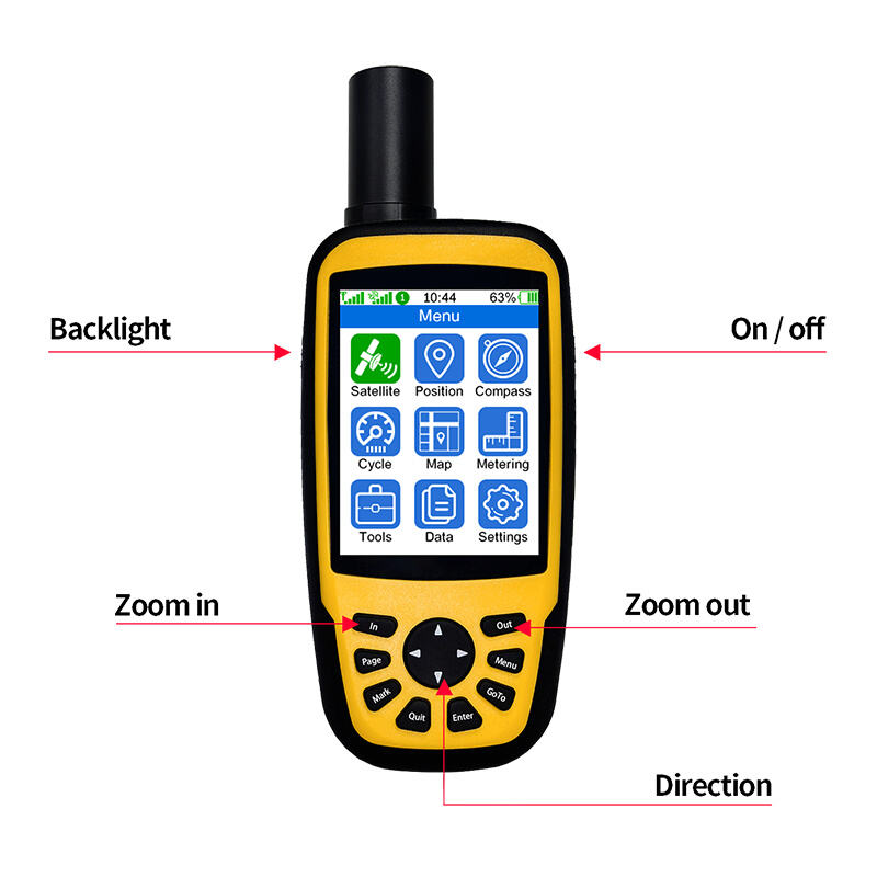
When considering RTK survey equipment, handheld RTK units are popular for their portability and ease of use. These devices excel in field navigation and are ideal for quick measurements and surveys in various conditions. Their compact design allows surveyors to easily maneuver through dense environments or large areas without bulky equipment. This portability doesn't compromise their function, making them a favored choice for many surveying tasks.
Base Station RTK Systems play a crucial role in surveying by providing a fixed reference for continuous monitoring and data collection. These systems are essential for establishing a reliable RTK network, enhancing accuracy over large areas. Primarily used in situations requiring long-term data collection, base stations support various application needs such as construction projects, cartography, and geodetic studies. These robust systems ensure the accuracy and precision required for precise mapping and plotting tasks.
Rover Devices, often used alongside base stations, enhance real-time surveying by allowing for dynamic, on-the-go data collection. Rovers connect wirelessly to base stations to receive corrections, thus improving accuracy. This setup is pivotal for operations that demand instantaneous feedback, such as topographic surveys and construction site assessments. The connectivity and precision rovers provide make them indispensable tools for modern surveyors. By leveraging these connections, surveyors can achieve high-precision data collection with minimal delays, crucial for industries like agriculture, construction, and civil engineering where precision is paramount.
When considering the price of RTK survey equipment, budget and investment considerations are crucial. The pricing of RTK equipment significantly varies based on user needs and the scope of projects. Basic models for small projects might be sufficient and cost-effective, while more advanced systems for large-scale, high-precision tasks can be more expensive. It is important to weigh the features and performance requirements against the budget constraints to determine the most suitable option for your specific needs.
Ongoing maintenance costs are another factor that influences the total cost of ownership for RTK survey equipment. Regular software updates ensure the equipment remains up-to-date with the latest technological advancements and bug fixes, while periodic calibrations maintain the system's accuracy. These recurring expenses, although not always immediately apparent, are vital for reliable performance and should be considered in the overall financial planning of RTK technology investments.
To support the financial aspects of investing in RTK technology, industry reports indicate that the adoption of RTK survey equipment is growing steadily, driven by its ability to provide centimeter-level accuracy essential for various applications, such as in construction and agriculture. The continuous enhancements in this field ensure that the value of RTK technology justifies the cost, especially in professions where precision is paramount. These financial insights can aid in making a well-informed purchasing decision.
When it comes to RTK survey equipment, the Cube RTK Small Volume High Precision Satellite Locator is a standout choice. This equipment is prized for its compact size, light weight, and high precision, making it ideal for both reference and measuring station applications. One of its most notable features is the built-in full-frequency satellite positioning module, allowing for comprehensive GNSS performance. It offers flexibility with two operational modes: base station and measuring station, and supports a wide range of communication methods including 4G, WiFi, LoRa, and Bluetooth.
The 660 Dual Frequency RTK Handheld Measuring Instrument is another noteworthy tool, designed with agricultural professionals in mind. It combines precision RTK technology with handheld convenience, supporting multiple GNSS constellations. This device excels in applications such as water source detection, field area measurement, and topographic surveying. It provides exceptional accuracy with features like multiple file format support and Bluetooth for seamless data transfer.
Lastly, the Cube RTK Small Volume Full System Full Frequency Satellite Locator delivers a comprehensive solution for professionals. Not only does it support a full range of positioning frequencies, but it also provides robust connectivity options and a substantial battery life of up to 15 hours. It stands out for its versatility in both base and measuring station functions, as well as for its innovative anti-loss feature, ensuring data security and equipment reliability across varied survey applications.
These products deliver reliable, high-precision performance tailored to diverse surveying needs, ensuring the ideal fit for professionals seeking advancement in technology and accuracy.
Finding reliable sources for purchasing RTK survey equipment can significantly impact your project's success. Major online retailers like Amazon and eBay offer diverse options from numerous brands, providing the advantage of competitive pricing and customer reviews. These platforms are excellent for buyers seeking a variety of choices and the convenience of online shopping.
Purchasing directly from manufacturer websites also has its perks. It often includes access to exclusive warranties and direct customer support, ensuring that you receive authentic products along with expert assistance. Manufacturers might provide detailed specifications and user guides that are crucial for making informed purchasing decisions.
Local dealers, on the other hand, add value by offering hands-on assistance, including demonstrations and installations, which can enhance user confidence. They usually have in-depth knowledge of the products they sell and can offer tailored advice based on your specific needs and conditions. This localized customer service can be particularly beneficial for those who prefer face-to-face interactions and personalized support.
The future of RTK surveying technology is set to be reshaped by advanced GNSS technology and the integration of drones. These innovations promise more precision and efficiency in field data collection, transforming how surveyors operate across various terrains. Concurrently, there's an increasing emphasis on sustainability, as eco-friendly practices and technologies aim to minimize the environmental impact of surveying activities. This focus not only enhances the sustainability of projects but also aligns with global environmental goals.


 EN
EN AR
AR NL
NL FR
FR DE
DE HI
HI IT
IT JA
JA KO
KO PT
PT RO
RO RU
RU ES
ES SV
SV TL
TL IW
IW ID
ID VI
VI SQ
SQ TH
TH TR
TR MS
MS IS
IS HY
HY UR
UR BN
BN MN
MN