In the field of exact positioning and navigation, Maskura Tech takes the lead with its advanced RTK (Real-Time Kinematic) positioning solutions. Designed for industries that require utmost precision, our systems enhance efficiency and reliability in tasks involving movement.
At Maskura Tech, we recognize how important accurate location data is within today’s technology-based sectors. To achieve centimeter-level accuracy in real-time, our systems for RTK positioning use state-of-the-art satellite navigation methods. Whether it is agriculture, construction industry, surveying or self-driving cars development; these solutions enable you to work with confidence knowing well that every part of your project will be done perfectly because you have all necessary information at hand.
The foundation of these rtk systems centers around two things; a dual-frequency receiver which helps correct signal errors and base stations or satellite systems providing correction data. This ensures that even when traditional GPS fails in places where signals are challenging due to environmental factors like buildings trees mountains among others , your operations do not get disrupted as they should remain on track always.
Our commitment to being innovative does not stop at accuracy levels only but also extends towards making them very user-friendly while still allowing for seamless integration into current workflows without much hassle involved on the part of end users themselves . Therefore what we provide here are hardware components which can withstand harsh conditions encountered during fieldwork plus software programs designed for this purpose ensuring consistent performance over time.
Whether one needs to navigate through difficult terrains , map out large areas or control machines accurately down to millimeters, Maskura Tech ‘s rtk positioning systems enable such capabilities thereby ensuring that each task gets performed precisely and efficiently .
Discover what could happen tomorrow when it comes to finding your way around by partnering with us at Maskura Tech using rtk positioning technology .
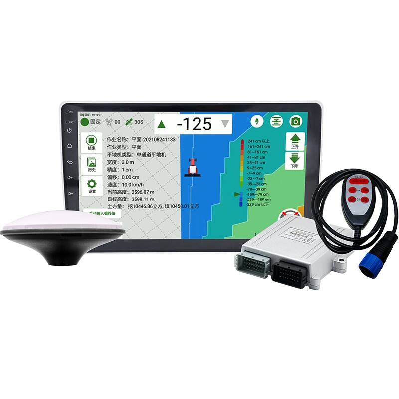
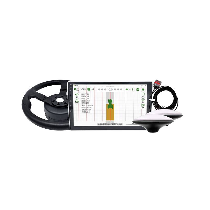
Shenzhen Maskura Technology, a renowned manufacturer of Hi-tech GNSS surveying equipment, has been at the forefront of innovation since its establishment in 2011. Specializing in a diverse range of products including RTK receivers, antennas, sophisticated software, land levelers, and autopilot systems, the company offers dependable and high-quality solutions to customers across the globe. With a focus on precision and accuracy, Maskura Technology's surveying equipment is trusted by professionals in various industries, ensuring accurate measurements and seamless operations. The company's commitment to excellence and continuous innovation has made it a leading choice for those seeking advanced surveying solutions.
Delivering cutting-edge technological advancements for diverse industries.
Ensuring superior product quality with rigorous testing and precision engineering.
Providing tailored solutions and excellent support to meet unique client needs.
Committed to meeting client needs with tailored solutions and exceptional support.
RTK (Real-Time Kinematic) horizontal positioning accuracy refers to the precision with which an RTK GNSS (Global Navigation Satellite System) receiver can determine its horizontal location on the Earth's surface in real-time. This accuracy is typically expressed in terms of distance, such as centimeters (cm) or millimeters (mm).
RTK achieves high accuracy by using correction data from a reference station, which is typically located at a known position. This correction data corrects errors caused by factors like atmospheric interference and satellite clock drift, significantly improving the accuracy of the GNSS receiver's position calculation.
For example, if an RTK GNSS receiver claims to have horizontal positioning accuracy of ±2 cm, it means that the receiver's calculated horizontal position should be within 2 cm of its actual position on the Earth's surface when using RTK corrections.
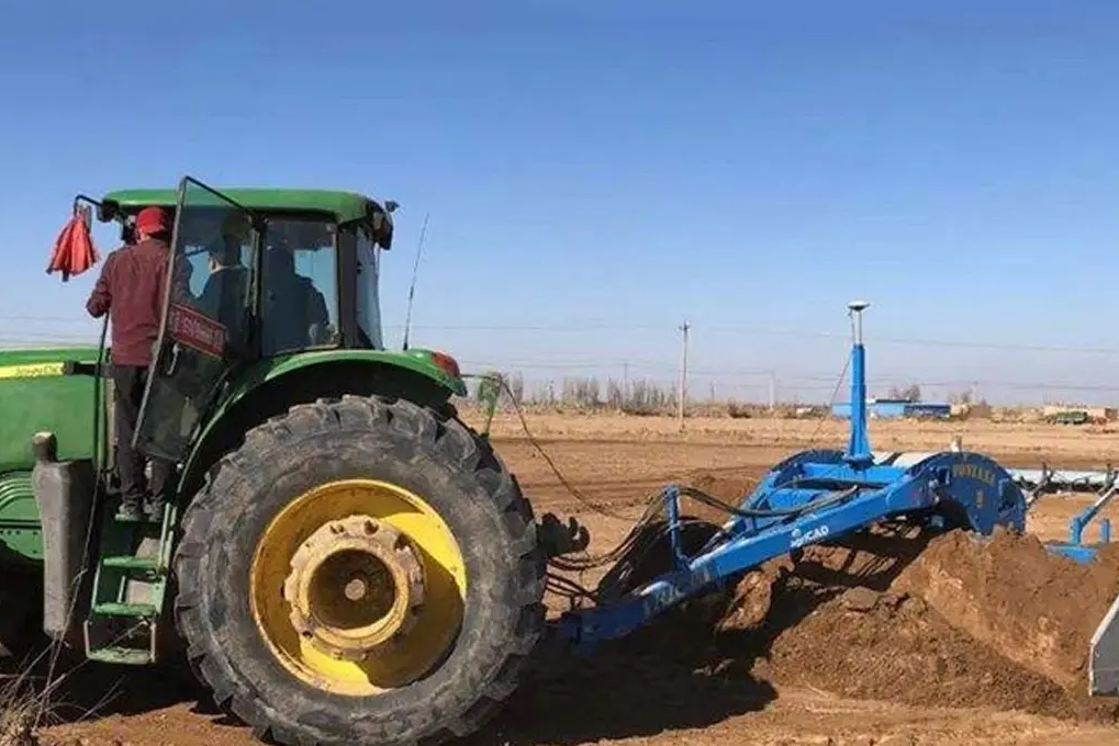
In applications requiring precise positioning, such as land surveying, construction, precision agriculture, and autonomous vehicles, RTK horizontal positioning accuracy is crucial for achieving reliable and precise location data.
RTK (Real-Time Kinematic) positioning is a satellite navigation technique used to enhance the accuracy of position data obtained from GNSS (Global Navigation Satellite System) receivers. It provides centimeter-level accuracy in real-time, making it valuable for applications requiring precise location information.
Here's how RTK positioning works:
Basic GNSS Operation: GNSS systems like GPS (Global Positioning System), GLONASS (Global Navigation Satellite System), or Galileo consist of a constellation of satellites orbiting the Earth. These satellites transmit signals that GNSS receivers on the ground use to calculate their position based on the time it takes for signals to travel from satellites to the receiver.
Error Sources: Several factors can affect the accuracy of GNSS positioning, including atmospheric conditions, satellite orbit errors, and clock inaccuracies.
RTK Enhancements: RTK improves accuracy by comparing the GNSS signals received by a rover (mobile receiver) with signals received by a reference station (fixed receiver) at a known location. The reference station precisely measures its position and sends correction data to the rover in real-time.
Real-Time Corrections: The rover uses these corrections to refine its position calculation, compensating for errors in satellite signals due to factors like ionospheric and tropospheric delays, satellite clock drift, and atmospheric conditions.
Achieving High Precision: With RTK, the rover can achieve horizontal positioning accuracy in the range of centimeters, often better than 5 cm horizontally and 10 cm vertically. This level of precision is essential for applications such as surveying, mapping, precision agriculture, construction site management, autonomous vehicles, and navigation in environments where precise location data is critical.
Usage: RTK systems typically consist of a base station (reference station) and one or more rover units (mobile receivers). The base station continuously monitors GNSS signals and sends correction data to rovers operating within its range. Some RTK systems can operate over larger distances using virtual reference stations or networked corrections.


 EN
EN AR
AR NL
NL FR
FR DE
DE HI
HI IT
IT JA
JA KO
KO PT
PT RO
RO RU
RU ES
ES SV
SV TL
TL IW
IW ID
ID VI
VI SQ
SQ TH
TH TR
TR MS
MS IS
IS HY
HY UR
UR BN
BN MN
MN