The Differential Global Positioning System (DGPS) is an enhancement to the standard GPS technology that significantly improves positioning accuracy. DGPS operates by using fixed ground-based reference stations to transmit the difference between satellite-reported positions and known fixed positions. This principle allows receivers to make corrections to their position data, substantially reducing positioning errors to within 1-3 meters, as documented in various studies. This level of precision is crucial for applications demanding accurate location data, such as surveying, navigation, and construction.
Real-Time Kinematic (RTK) GPS is a satellite navigation technique designed to further enhance precision by combining satellite signals with data from a fixed base station. This dual-source reliance allows RTK GPS to perform real-time corrections, drastically improving accuracy to less than 2 centimeters of error. According to studies, RTK systems offer a remarkable advantage over traditional GPS, especially in high-stakes environments like surveying and construction where centimeter-level accuracy is needed.
DGPS and RTK form a powerful partnership for precision tasks, where RTK serves as an advanced extension of DGPS to deliver even greater positional accuracy. DGPS can lay the groundwork by initially improving accuracy to a manageable level, thereby aiding RTK systems in achieving finer precision essential for detailed surveying or machine guidance applications. Together, these systems enhance the reliability and performance of position-based applications, enabling users to achieve superior results across various industries. Through these collaborative techniques, users can gain confidence in the accuracy and consistency of their data, further optimizing workflows and outcomes.
An RTK base station plays a crucial role in enhancing positional accuracy by calculating real-time corrections. Positioned at a known, fixed location, these stations continuously collect data and use sophisticated algorithms to compute precise correction information. This data is then relayed to mobile RTK units, effectively reducing positional errors caused by atmospheric disturbances and satellite inaccuracies. The success of an RTK base station hinges on its proper placement, ensuring it has a clear view of the sky to maintain uninterrupted communication with satellites. A well-operating base station is essential to ensure optimal performance and accuracy in RTK surveys.
NTRIP, or Networked Transport of RTCM via Internet Protocol, revolutionizes how real-time RTK corrections are delivered. By using the internet, NTRIP facilitates seamless access to correction data, overcoming the limitations of traditional radio- or satellite-based transmissions. This modern approach not only enhances accessibility but also allows multiple users to harness the same correction data across extensive survey areas simultaneously. For example, NTRIP's application in large-scale agricultural projects showcases how it enhances accuracy and efficiency, providing invaluable real-time corrections to support precision tasks over complex terrains.
To achieve centimeter-level accuracy with RTK systems, several technical conditions must be met. Essential factors include favorable atmospheric conditions and optimal satellite geometry, which can significantly impact RTK precision. Additionally, the use of high-quality, precise equipment is critical. According to authoritative sources, RTK generally achieves an accuracy level of 1 cm + 1 ppm, enabling exceptional precision in various applications. However, it is important to continuously monitor environmental and technical variables, as they can still influence the performance and accuracy of RTK-enabled tasks.
DGPS GNSS RTK systems significantly enhance surveying accuracy, pivotal for achieving precise outcomes. These systems are crucial in applications like boundary delineation and construction staking, where precision is non-negotiable. For instance, in boundary marking, accurate measurements ensure exact position definition, avoiding disputes. A case study by the Journal of Surveying Engineering detailed how incorporating RTK technology in urban planning led to a 95% reduction in boundary-related disputes. This demonstrates the transformative impact of RTK in improving surveying accuracy, leading to more reliable and error-free outcomes.
The automated data correction processes inherent in DGPS RTK systems help eliminate many human errors traditionally associated with surveying. This technology simplifies complex calculations, reducing the chances of costly mistakes. For example, human errors in stake placement during construction can result in significant financial implications. Studies have shown that integrating RTK technology reduces errors by up to 70%, according to research by the American Society of Civil Engineers. Technology not only simplifies processes but also ensures that every movement and measurement is accurately captured in real-time, boosting overall efficiency and reliability.
Implementing DGPS GNSS RTK systems proves to be a cost-effective solution when compared to traditional surveying methods. While the initial setup may seem steep, the long-term savings in terms of accuracy and reduced reworks outweigh the cost. Organizations have reported a noticeable return on investment, as precise measurements prevent future corrective expenses. For instance, in a survey of construction projects using RTK systems, firms experienced a 20% decrease in project delays and cost overruns as noted in a report by the International Journal of Construction. This highlights that investing in RTK technology not only saves money but also enhances the predictability of project timelines, ensuring smoother project completions.
DGPS GNSS RTK systems have revolutionized land surveying and mapping by significantly enhancing precision and speed. These innovations are particularly crucial in scenarios requiring high accuracy such as urban development projects and environmental assessments. For instance, in urban settings where every inch of land matters, the use of RTK technology ensures that boundary lines are drawn with precision, reducing the likelihood of disputes and errors. There are numerous case examples where projects that utilized RTK technology attained high-precision mapping results, enabling smoother and more effective project completion.
In the realm of construction site management, RTK plays a pivotal role by optimizing equipment positioning and layout. With precise location data, construction site teams can improve workflow efficiency and minimize downtime, enhancing the overall productivity of a project. For example, the precise placement of machinery based on RTK data allows for seamless operations, reduced material wastage, and adherence to design specifications. Real-world applications have demonstrated that integrating RTK systems into the construction process leads to successful project completions within set time frames and budget constraints, contributing to increased industry adoption.
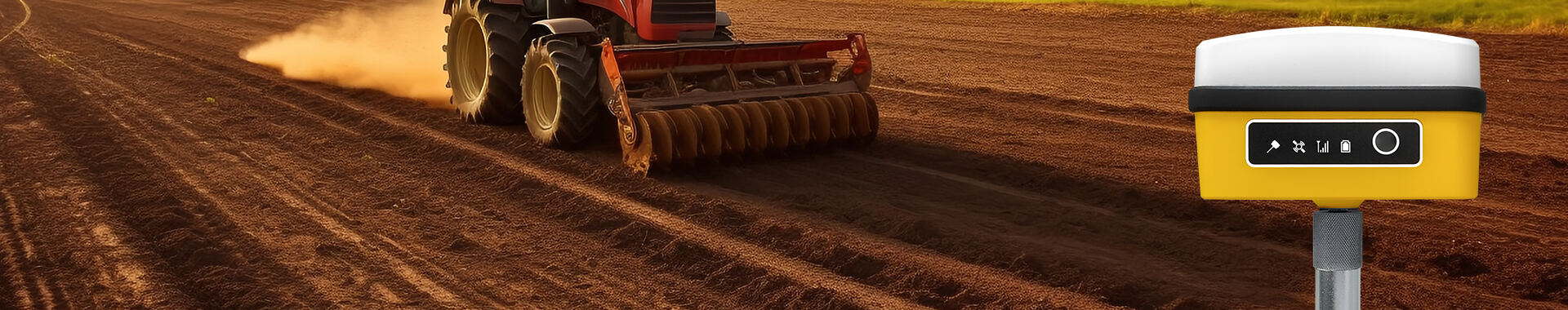
DGPS GNSS RTK systems are essential in precision agriculture, allowing for optimized field management and increased crop yields. Technologies, like auto-steering tractors and variable rate application of fertilizers, benefit immensely from the high-accuracy data provided by RTK. These systems enable farmers to apply fertilizers and seeds with pinpoint accuracy, resulting in efficient use of resources. Statistics show substantial improvements: certain practices have led to increased yields by up to 30% or resource reduction by as much as 20%. Thus, RTK technology supports sustainable farming through advanced precision agriculture.
When choosing an RTK setup, evaluating the compatibility of RTK receptors is crucial to ensure they work seamlessly with existing systems. This involves assessing the specifications, including frequency support and communication protocols. For instance, popular models such as the Trimble R10 or Leica GS18 I offer excellent compatibility features, supporting multiple GNSS frequencies and protocols like NTRIP. By understanding these specifications, one can avoid potential compatibility issues and ensure that the RTK system integrates smoothly with the existing setup.
Geographical coverage is a key aspect when selecting a DGPS GNSS RTK system as it can significantly impact the effectiveness of the system. In urban settings, factors such as signal interference from buildings are common, while in rural areas, satellite visibility might be more challenging. When setting up in diverse environments, it's important to conduct signal tests to dictate the appropriate positioning of RTK base stations. Case studies, such as a project in New York City, highlight how geographic constraints can decide RTK deployment, ensuring efficient signal reception and robust performance.
Budgeting for RTK systems encompasses costs related to both initial acquisition and ongoing maintenance. Hardware investments and subscription fees for services like NTRIP need careful consideration. It's crucial to align spending with project demands and the anticipated return on investment (ROI) gained from improved accuracy and efficiency. Savvy purchasing decisions, like looking for used high-quality equipment or leveraging discounts on subscription packages, can make obtaining top-tier technology feasible without excessive expenditure. Such strategies help balance financial constraints with the need for technological excellence.


 EN
EN AR
AR NL
NL FR
FR DE
DE HI
HI IT
IT JA
JA KO
KO PT
PT RO
RO RU
RU ES
ES SV
SV TL
TL IW
IW ID
ID VI
VI SQ
SQ TH
TH TR
TR MS
MS IS
IS HY
HY UR
UR BN
BN MN
MN